Senin, 24 Januari 2011

Situ Cileunca and Mystical Stories

SITU Cileunca located 45 km south of Bandung city, not far from the City District Pangalengan. Puddle of water covering an area of 180 hectares was sandwiched between two villages, namely Warnasari and pulosari. "Actually, Situ Cileunca that there are two pieces. Cileunca One has an area of 210 hectares and this, Situ Cileunca Two, has an area of 180 hectares, "said Asep Jabog (50), one of the local community leaders, to" PR ", recently.

He recounts, first, Situ Cileunca is a Dutch privately owned areas. "His name Kuhlan," he said.


Development was held there for 7 years (1919-1926) in a way to stem the flow of time Cileunca. "Interestingly, based on the narrative old people first, there was built by many people. Do not use a hoe, but using Halu, "he said.

There is development, he said, commanded two smart people, namely Arya and Mahesti renowned as the Juragan. So, not surprisingly, the tomb Mahesti be a place sacred by the local community. "The question of who like to visit, not just people here, but there are many people from outside," said Ade Rowi (35), one of the boatmen there.

There are many mythical stories in Situ Cileunca. One that is often heard is "puppet show". Asep Jabog justify it. "But, now, is rarely heard. First, based on the story, there is a group of drummers wayang (puppet masters following the sinden and nayaga.) who drowned in Situ Cileunca. Since then, people often hear a strange sound. In fact, no nothing, "said Asep.

Asep also said, in fact, there are two famous stealth in Situ Cileunca. Lulun Samak and Dongkol. Lulun Samak is "something" that kill their prey by rolling. Meanwhile, Dongkol is "something " tangible head of buffalo.

"But, now, they are no longer here. I hear, is in Situ Bagendit. You see, this Cileunca Situ 'associated' with two other situ, ie Bagendit and patengan. Just see, if Cileunca recede, others are also receding, "said Asep Jabog.

Until now, the story of the mystical in Situ Cileunca still ongoing. Of course, in its early stages that are not harmful. "Yes, do not be surprised when camping here is that suddenly appear," said Asep.


One thing he is worried about is the situation heats up tourist attraction. In the assessment, placement in Situ Cileunca resort complex is not appropriate. So, ask tumbal. I am afraid, tumbal requested that happens in the near future. You see, the situationin of late ,is heating up, " said AsepJabog

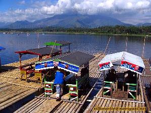
In the afternoon, especially when the sky is clear, Situ Cileunca really pamper visitors with its natural beauty. From the top of the speeding boat slowly in calm water rippling lake, visitors can rotate the view, gazing at the green expanse of tea plantation. Far away, three mountain stood with conceited. Mount Malabar, Wayang Windu Mt.

"In the evening, here too crowded. Many prostitutes. Not the usual prostitute. Covered delicious, "Ade Rowi say. Do not mock him. Still do not know exactly how many prostitutes there, Ade said could bring the customer. Residence coordinator contacted. "Regarding the place, most people use the facilities at the village boat across the lake. Rent, Rp 150,000 a night, "he said.

He said the sex workers who were there did not apply aggressive. In their daily life, they move as usual. Evening all, they do not wander, aggressively looking for customers. "Well, if there is a message, then they leave the house. If not, it stayed at home, "he said.


Most, he said, sex workers is a product of divorce at the age of the young. "The issue of tariffs, so at most Rp 50.000,00 up to Rp 150,000," said Ade Rowi

Source : Harian Pikiran Rakyat 
Foto : siswa.univpancasila.ac.id
mahanagari.blog.friendster.com
pdkbmajalaya.blogspot.com

Situ Bagendit

Visiting attractions Situ Bagendit is not difficult. Smooth asphalt road since the town of Garut allows all sorts of vehicles can be used to get there. Bagendit Situ own name came from the local folk legend. Situ means small lake, while Bagendit Nyai Endit taken from the name. Nyai Endit was a wealthy widow, greedy, greedy, and pretentious power in his village. Because of greed, one day an old beggar teach him a lesson. As a result, homes and all possessions Nyai Endit washed away by water.

This tourist attraction has the potential of natural scenery which is quite interesting, a large lake with a backdrop of towering mountains terlimuti cloud on top looks beautiful eyes. Some rafts made of bamboo with a roof and seats are colorful, ready to take visitors to navigate the lake. Not only raft, small boat and canoe-shaped goose is also provided for those who want more privacy in enjoying the journey across the lake. A collection looks blooming lotus flower in one corner of the lake.


While the lake itself, it seems some visitors cool to throw the hook, hoping to get the fish. A group of visitors cool shade under the trees shade as he held a mat and ate lunch. A miniature railway is also available as one of the other forms of entertainment available. Unfortunately, the path through which is not far away and less interesting, because just round and round in a short distance and circled the place filled by the visitors and vendors / traders foot-five. Where the train is spinning can still be seen from many places, some proof that the spectacle offered when boarded the train is not much different from people who just sit or stand at the site. Had the train route even further, say around Situ Bagendit or just half of it would be more interesting to try.

A swimming pool which is on the edge Situ Bagendit also no longer function properly. The color of existing water in the pool has been turned into brown. They say the water from the swimming pool is mixed with water seepage originating from Situbagendit, something that did not need to happen if planning and construction of ponds has been done well. When I visited Situ Bagendit early January 2005, the swimming pool had been closed to the public. it is very unfortunate given that the budget had been disbursed for the construction of a tourist attraction Situ Bagendit reached 700 million *.


Surely a more serious treatment in the management of this tourist attraction will be able to suck up the number of visitors more. Because after Bagendit Situ naturally and is potentially very interesting place to visit, terelbih at a time when the sun rise / set, seems to be able to give the feel of its own for visitors.

* source: Harian Pikiran Rakyat
foto : zairgad.blogspot.com
pasundan.info

Jumat, 07 Januari 2011

Mount Galunggung

Mount Galunggung (Indonesian: Gunung Galunggung, formerly spelled Galoen-gong) is an active stratovolcano in West Java, Indonesia, part of the Sunda Arc extending through Sumatra, Java and Bali, which has resulted from the subduction of the Indian oceanic plate and the Australian plate beneath the Eurasian plate.

Eruption of 1822


Starting 8 October 1822 Galunggung began an explosive event that lasted over a month, reaching an estimated VEI of 5[1] and producing lahars that killed more than 4000 people.[2] Pyroclastic flows extended almost 10km (6 miles) from the volcano

Hazardous eruption of 1982


The last major eruption on Galunggung was in 1982, which had a Volcanic Explosivity Index of 4 and killed 68 people. This eruption also brought the dangers of volcanic ash to aviation to worldwide attention, after two Boeing 747 passenger jets flying downwind of the eruption suffered temporary engine failures and damage to exterior surfaces, both planes being forced to make emergency landings at Jakarta.
One, a British Airways aircraft carrying 240 passengers, accidentally entered the ash cloud during night time in June 1982 150 km downwind of the volcano. All four engines failed and the aircraft descended for 16 minutes, losing 7,500 metres of its 11,500-meter altitude, until the crew managed to restart the engines.
The following month a Singapore Airlines aeroplane with 230 passengers aboard also inadvertently entered the cloud at night time, and three of its four engines stopped. The crew succeeded in restarting one of the engines after descending 2,400 metres. Both aircraft suffered serious damage to their engines and exterior surfaces

 Sourch : Wilkipedia

Mount Kerinci

Mount Kerinci (also spelled Kerintji, among several other ways, and referred to as Gunung Kerinci, Gadang, Berapi Kurinci, Kerinchi, Korinci, or Peak of Indrapura as well) is the highest volcano in Indonesia, and the highest peak on the island of Sumatra. It is surrounded by the lush forest of Kerinci Seblat National Park, home to the endangered species of sumatran tiger and sumatran rhinoceros.

Geography

Kerinci is located in Province of Jambi, the west central part of the island, in the Pegunungan/Bukit Barisan, near the west coast, and is about 130 km (81 mi) south of Padang. It is the most prominent feature of the terrain of Kerinci Seblat National Park, with pine-forested slopes rising 2,400-3,300 metres above the surrounding basin, and a cone 13 km (8 mi) wide and 25 km (16 mi) long at the base, elongated in the north-south direction. At the summit there is a deep 600 m (1,969 ft) wide crater, often partially filled by a small crater lake on the northeast side of the crater floor

Volcanic activity

Kerinci is more active than most Indonesian volcanoes, with nearly annual phreatic eruptions. Kerinci last erupted in 2004, and continues to spew clouds of sulphurous smoke, with plumes reaching as high as 1,000 m (3,281 ft) above the summit. While there is farmland in the area, and a tea plantation on its southern slope, Kerinci, being located in an Indonesian national park, and perhaps out of respect for its frequent growlings as well, sits in an area that is sparsely populated by Indonesian population-density standards.

Climbing

Kerinci can be climbed from the village of Kersik Tuo, 6 or 7 hours away from Padang by car or bus. The climb and descent normally takes 3 days and 2 nights, if you choose to go to the summit. You may also choose to go up only till Camp 2 or 2.5, skipping the summit attempt which is a night climb; and take 2 days and 1 night instead.
As of November 2007, the alert level for Kerinci was raised to Level 2- Orange, due to black smog seen coming out of the crater. But climbing the volcano is still relatively safe and allowed; though you may not climb any further than 1 km to the crater.
Kerinci's terrain consists of thick jungle, it can get muddy and slippery even if there are only mild drizzles, which may occur occasionally even during the dry season. To climb the volcano you need a guide, for there have been rare cases of people disappearing after attempting to trek alone.

Sourch : Wilkipedia
foto : ekspedisinet.blogspot.com

Mount Lawu

Religious Travel to Mount Lawu

Wonderful Sunrise from Mount Lawu
The gate of Mount Lawu lies in lines that connect Magetan-Solo through Tawangmangu, so this vacation spot can be reached both from Magetan, or from Karanganyar.
There are two prominent purpose of traveling here,
  1. to enjoy the beautiful scenery, the nature’s forest with it’s unique flora and fauna, and it’s clean and cool air, or
  2. as a part of ritual vacation. In Mount Lawu there are a lot of historical sites as inheritance of King Brawijaya V of Java./ Majapahit kingdom

Peak of Mount Lawu
Peak of Mount Lawu
Travel to peak of Lawu can be defined as a typical kind of interest. It is said that King Brawijaya V had got his vision during his journey to the peak of Mount Lawu.
That is why, nowadays the society do the religious travel ritual, especially those who celebrates new year as part of Javanese culture. The amount of visitors will come to top on Javanese new year, which comes in the night of 1st muharram or 1st of Suro ( Suro is a name of Javanese calendar, it is the first month of the year, while Muharram is arabic term for this date ).

Sourch : Exotic Tour

Mount Papandayan

Mount Papandayan is the southest of Mountain Range which ranging from the South Part of Bandung city. Mount Papandayan is quite popular in West Java for it’s beauty and unique scenery.
Some facilities to reach this mount has been built, like some asphalt roads to make it easy to get to the area. Tourist Guides are also provided. It is suggested to use their service, especially to those first-timers.

Taking steps in Mount Papandayan must be aware of. The soil is sometimes very soft. We can see some breaking on the white soil with thick haze.

Beautiful scenery along the mount climbing which can be seen is a colored natural lake. This is a natural green lake which still spills out strong scent, which comes from the sulfuric layer under the lake. Mount Papandayan is an active volcano, here, the role of a guide is very needed. For family vacation, a guide is very much recommended.

In a certain height, we can find the famous Edelweiss. Edelweiss is called as “the eternal flower”, because it is never wilted. Edelweiss has a typical aroma too
 
Sourch : Exotic Tour

Mount Jayawijaya


At first, Mount Jayawijaya is called Mount Top Sukarno ( Puncak Sukarno in Indonesian) .
Jayawijaya is one of the Sudirman’s Mountain Range ( Barisan Sudirman in Indonesian ), and is the second highest mount in South-East Asia, and has been one of World’s Premiere Seven Mount Top
Other Spelling for Mount Jayawijaya are :
  • Ngga Pulu
  • Mount Carstensz
  • Carstensz Pyramid/Top Pyramid
  • Carstensz Top/Mount Top
  • Jayakesuma Top/Mount Top
Around Mount top of jayawijaya there are still another three next tops, namely Top Soemantri (4.855 M) ( Puncak Sumantri ), Top East Carstensz (East Carstensz, 4.775 M) and Middle Peak ( Puncak Tengah )
Mount Jayawijaya. It is hardly to imagine sometimes that the tropics country like Indonesia has a snowy spot. More over the eternal snow one. Like this one, it is called Mount Jayawijaya.
Mount jayawijaya lies on 4862m sea level, in province of Papua. The height of the mountain top has made Mount Jayawijaya’ Top be eternally snow-capped.

At first, Mount Jayawijaya is called Mount Top Sukarno ( Puncak Sukarno in Indonesian) .
Jayawijaya is one of the Sudirman’s Mountain Range ( Barisan Sudirman in Indonesian ), and is the second highest mount in South-East Asia, and has been one of World’s Premiere Seven Mount Top
Other Spelling for Mount Jayawijaya are :
  • Ngga Pulu
  • Mount Carstensz
  • Carstensz Pyramid/Top Pyramid
  • Carstensz Top/Mount Top
  • Jayakesuma Top/Mount Top
Around Mount top of jayawijaya there are still another three next tops, namely Top Soemantri (4.855 M) ( Puncak Sumantri ), Top East Carstensz (East Carstensz, 4.775 M) and Middle Peak ( Puncak Tengah )

Sourch : Exotic Tour
foto : belindo.com